 Q. How can I move a boundary?
A. This will require a boundary adjustment survey. There are several steps to the process; you should contact us and we can guide you through. Click for more details on Boundary Adjustments.
A. This depends on where you live; the local Council will have a specific zone for your property, and associated rules on subdivision for that zone (primarily based on land area). You should give us a call and we can assess your property to see what is feasible. Click here for more detail on our subdivision services.
A. You need an accurate plan of your site by undertaking a site survey. Click here for more information on site surveys.
A. We have all of the skills and equipment to pinpoint your new dwelling. We can provide builders with accurate building corners or grid lines, and even set out internal walls for plumbing. We can save your builder lots of time with a quick and accurate building set out. Click for more information on Land Owner Sureying Services
A. To be certain your hard work and expense is located correctly, you should call us and arrange to locate your boundary line. Even if you have found your boundary pegs, they may have been damaged or moved. We can check the existing pegs or provide new pegs or temporary marks depending on your requirements. For more details on Boundary Location click here.
A. Yes, we can provide a variety of advice and services to assist; this might include a site survey, computer model of the excavation, determination of volumes, application for resource consent, management of an earthworks contract, and set out for the digger driver. Click here for more information on our earthworks modeling and volumes services.
A. Sounds like you're going to require a Boundary Location Survey. Our team has access to the necessary survey plans and documents, along with the qualifications to locate your boundary and eliminate any guesswork. For more Boundary Location details click here.
A. This falls under Easements. Typical examples are for power cables, water lines or vehicle access (right of way). Click for more details on easements and how we can help.
A. Yes, this falls under our civil engineering expertise. Our surveyors have the knowledge and experience to prepare the necessary civil design for your land development. Click here for more details on civil engineering.
A. The Resource Management Act (RMA) is the fundamental legislation that dictates the process of land development and subdivision in New Zealand. For more details on how we can help you with the RMA, click here.
A. Yes, our equipment can measure to most objects up to approximately 200m distant.
A. Most survey tasks are unique; for example, the time and complexity of a job will be influenced by the age of your suburb, since that relates to the size of trees and vegetation which can hinder our ability to take measurements. Typically our costs will be charged on an hourly rate basis. Our rates will vary depending on the experience of the staff involved and the type of equipment being used. Give us a call and we can discuss your requirements to determine costs.
A. Land Information NZ is the government agency that provides a regulatory framework for defining, and dealing in, property rights in land. It maintains publicly available core geographic and survey information that underpins property rights in land and manages land-related liabilities on Crown land.
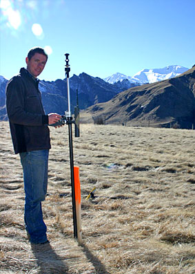
A. Global Positioning System. In simple terms, there is a bunch of satellites whizzing overhead that emit signals. Our survey accurate receivers can use those signals to measure positions. Another term, GNSS (Global Navigation Satellite System), is also developing as more countries add additional satellites. Our Trimble GPS receivers provide accurate measurements down to mere centimetres, and are incredibly efficient where the conditions are favourable; don't expect them to work so well under trees or close to tall buildings.
A. Some people are familiar with the term theodolite; an instrument for measuring angles (both vertically and horizontally). If you add electronic distance measurement (EDM) capability to a theodolite, you get a total station; which measures angles and distances to someone holding a reflecting prism. Now, take it a little further and add some little motors to automatically turn the total station so it follows the movements of the prism; now you have a robotic total station. We have a couple of these super efficient and accurate instruments in our fleet.
Still not sure? Contact our friendly team and we can help you in person.